|
��Ʒ���� |
|
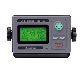
���� SAMYUNG ENC SPR-1400 GPS���ǵ�����
����
���շ�ʽ:12ƽ���ŵ�
����Ƶ��:1575.42MHz(C/A��)
��ȷ�ȣ�
(1)GPSģʽ:
�����10��(2D RMS HDOP��2 (SA��))
(2)DGPSģʽ:
�����3��(2D RMS HDOP��2 (SA��))
��������0.1��(2D RMS HDOP��2 (SA��))
��·�����:100��
�����������
(1)NMEA 0183,SAMYUNG ENC,FURUNO(CIF),JRC(RS-232C)
(2)DGPS(������ǵ�����)�ź�����
(3)����������ݲ���WGS-84����ϵ
���������¶ȣ�
(1)��ʾ��:-15��~��55��
(2)����:-30��~��85��
�����������ʪ��:0~95
��Դ:10-40VDC
����:��20W |
Features
• Compliant with IMO and MSC standard.
• Small size, Light weight, Easy installation.
• All data with big letters can be displayed in one screen.
• Interface with PC to print out destination, mark and routes.
• No need to initially set-up the machine as it is of full automation.
• Easy night navigation with full light support in screen at every stage.
• Has temporary plotter function.
• WGS-84 and other way of geodetic survey can be selectable.
Specifications
• Receiver Frequency : L1 1575.42 MHZ (C/A code)
• Display Resolution : 128��64 dot LCD(3inch)
• Receiving Type : Digital 12 Channels multi tracking type
• Receiving Sensitivity : below -130dBm
• Resolution : 1/1000 Lat. and Longitude
• Accuracy : In case of GPS,
Position : 10m 2D RMS (HDOP�� 2)( SA OFF)In case of DGPS,
Position : 3m 2D RMS (HDOP�� 2)( SA OFF)
• Speed Accuracy : 0.1Knots RMS(HDOP<2, SA OFF)
• Destination Memory : WAYPOINT/MARK/MOB 1000 points in total
• Mark : position, course, average speed, destination, accessing speed,
name of destination, route navigation, distance to destination,
direction, time reguired, secession from route
• Display Mode : Temporary plotter mode, Steering mode, Highway mode, Navigation Data mode,
User mode(Digital, Speedometer)
• Plotter mode : 0.02, 0.05, 0.1, 0.2, 0.5, 1, 2.5, 19, 20, 50, 160, 320nm
• Highway mode : 0.2, 0.4, 0.8, 1, 2, 4, 8 16nm
• Temperature : Main : -20��~+55��, Antenna : -40��~+85��
• Relative moisture : 0~95%
• Input/ Output of Data : - INPUT RS-232C, OPUPUT RS-232C & TTL
- SAMYUNG, NMEA 0183(Ver1.5, 2.0), FURUNO(CIF), JRC
• Power Supply : DC 10 ~ 36V / 0.08~0.3A(Max. below 4W) |