|
|
| |
|
| |
|
|
| 电 话: |
+86-21-6100-9517 |
| 传 真: |
+86-21-6100-9516 |
| 联系人: |
梁先生 |
| 地 址: |
上海市浦东新区民冬路166号4 |
| |
幢5楼东侧 |
| 电 邮: |
shaihappy@126.com |
| |
shanghaihappy@126.com |
|
|
|
|
| |
|
|
| 产品展示 |
|
 |
|
|
| JRC JAN-901B |
 |
| |
|
|
 |
|

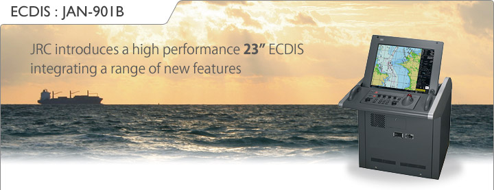
The JAN-901B is a newly developed multi-functional ECDIS. It is ergonomically designed to enhance the working environment and man/machine interfaces, providing continuous position and navigational safety information.

The JRC JAN-901B offers practical radar usage with ECDIS, more than just overlaying a rough radar image. The radar image has a high resolution when interfaced with JRC radars. The radar image does not hide the priority objects of vector charts, but overlays them on the radar image. At the same time, brilliance and clutter controls of the radar images continues to be operable. |
 |
 |

The AIS is an important key device used to indicate AIS target symbol and information on the ECDIS. These targets are very useful, as it provides the maneuvering conditions of other ships at a glance, allowing for safe and effective navigation. The name of the vessels, and bearing, range, speed, length, heading and much more AIS target specifics from other ships are received and displayed. The AIS symbols are continuously displayed on-screen without the influence of the radar characteristics. The AIS targets are never shielded by ground, rain or cloud reflections, nor are they eliminated by adjustments of anti-sea or anti-rain clutter. |
| Also, it is easy to active, deactivate and switch between AIS target symbols. This simply can be done with an integrated AIS filter, prioritising the targets within a dedicated area. |
 |

Multiple and wide screen viewing is possible with the new JAN-901B. You can divide the chart screen into two sections, in which the same or different charts can be displayed, in a mixture of ways. In this field of view, it provides a ‘look-ahead’ capability, especially useful in coastal areas. With the wide screen view function, an additional screen in the display area, showing a segment of the chart, allows viewing at a glance. |
 |
 |

You can easily connect a wide range of navigation equipment to acquire more information. The ECDIS will display exactly the info you need in a clear, uncluttered format, reducing the risk of accidents. This results in a more relaxing and secure operation. Even equipment from different manufacturers can be incorporated. |
|
|
|
 |
|
|
|

The new keyboard design of the JAN-901B allows you to carry out all operations simply by using the keyboard or on-screen by use of the trackball.
 |
The responsive feel keys allow logical and precise operation and also integrate function keys for one-touch access to VIDEO, RAIN, SEA and GAIN. This makes is seamlessly to navigate through all commonly used tasks. |

The JAN-901B 23-inch colour display is able to show bright, high resolution imagery. With a press of a button, the screens’ brightness can automatically be adjusted to the most optimal condition. You can also select from multiple background modes e.g. day/dusk/ night, a practical feature which facilitates a clear sight, this in view of the ever changing lightening conditions on the bridge. |
 |

As set by IMO regulations, a Consistent Common Reference Point (CCRP) is a location on own ship, to which all horizontal measurements, such as target range, bearing, relative course/speed, closest point of approach, or time to closest point of approach are referenced.
 |
Where multiple antennas are installed, different position offsets for each antenna in the radar system should be applied with respect to the CCRP.
If you switch between scanners (up to 8 possible - option), the information displayed is generated allows for consistency and uniform output. This new feature is easily accessible from the menu. |

The JAN-901B incorporates two Tornado™ processors, which are exclusively developed and designed by JRC, bringing a new level of performance and reliability to ECDIS operation. The new Tornado™ processors, which equal the power of eight conventional processors, allow radar overlay processing within a few milliseconds before displayed. This generates a smooth and fast image update. The advanced system architecture, make the JAN-901B series probably the most sophisticated ECDIS available today.

The ECDIS system is available in stand alone and desktop versions to suit your type of vessel. In the desktop version, the processor unit is the heart of the JAN-901B, allowing for flexible installation approach in confined spaces.

With its simplified menu structure, the new JAN-901B shares the same insightful user interface as found in JRC’s new radar series. The consistent visual appeal and intuitive usage is of great importance on the vessels bridge, especially being a working and living environment for thousands of vessels’ officers on a day to day base. |
 |

The advanced nature of JRC’s new ECDIS system allows route planning in different ways. Either plan your route by using the table editor, while displaying current waypoint or graphically draw your next waypoint on the chart. Editing the route is just as simple as inserting. Dedicated menus are readily available to assist the mariner in effective route planning. Not only can you save the routes, but import favourite or commonly used files, even from previously ECDIS models, using industry-standard CSV format.
During the voyage, you can add an alternative route, which can be displayed simultaneously. You can move, insert, add and delete waypoints instantly and easily exchange the alternative route with route in progress, at your own convenience. |
 |

The JAN-901B provides a rich suite of objects which you single-handedly can enter, move, insert and add on user maps.
 |
The objects consist of symbols, lines, areas and texts. From buoys to buildings and harbour to seabed signals, JRC’s new ECDIS has a total of over 40 categories and 30 sub-categories, which include more than 250 graphics readily available for endless possibilities.The user map is linked to the chart, and even if there are multiple user maps, you can easily select or merge. |
 |
A few examples |

The vessels’ primary position is saved with a minimum interval of three seconds, and the tracking period on the chart is displayed up to 24 hours. Conveniently mark your past track, choosing out of seven colours, eight tracking periods, ten time intervals and eight nautical mile presets. |
 |

Some items could strike you on the vessel, a slippery deck or unexpected movement of the vessel are situations in which a person may possibly fall of the vessel. The JAN-901B integrates a single-press Man OverBoard (MOB) operation. Instantly, a dedicated symbol arises on the screen, providing a range detailed info such as positioning, bearing, range and time till arriving at MOB. This emergency system enables immediate and accurate search and rescue efforts. |
 |
|
|
|
|
|
|
| |

| Model |
JAN-901B |
| IMO compliant |
 |
| General |
|
OS |
Windows XP embedded |
| Power supply |
AC 100-115, 200-230 V ±10%, 60/50Hz ±5% |
| Power consumption |
300VA or less |
| Display |
|
Size |
23” colour LCD display |
| Resolution |
1600x1200 dot (UXGA) |
| EBL |
2 (EBL1/EBL2) |
| VRM |
2 (VRM1/VRM2) |
| Bearing indication |
north-up / course-up (simultaneously in multi view) |
| Presentation mode |
true / relative / free motion |
| Multi display areas |
2 (longitudinal, transverse, picture in picture) |
| Scale |
1:1.000 up to 1:75.000.000 |
| Range |
0.125 - 120nm |
| Route planning |
|
Input |
graphical or numerical |
| Safety check |
grounding, obstruction, dangerous areas |
| Import/export format |
CSV |
| Limit check |
1)TCS only: turn radius, route width |
| Monitoring |
|
Plotting |
Own vessel position and track |
| ARPA tracking |
200 |
| AIS tracking |
300 (sleeping + activated) |
| AIS class |
class A + class B |
| AIS/ARPA alarm |
CPA/TCPA |
| Chart management |
|
Updating |
semi-auto / manual (available via ChartCo) |
| Data correction |
available |
| Conning display |
|
Navigation screen |
date/time, speed, route planning info, engine data, rudder data, weather/sea conditions |
| Harbour/docking screen |
speed, docking/sway speed, thruster data |
| Alarm management screen |
complete and detailed alarm status, acknowledge |
| Interfaces |
|
Gyro input |
2)IEC61162-2 or synchro/step |
| Log input |
2)IEC61162-1 or 200 pulse |
| Remote maintenance |
possible |
| Copying route |
FD / USB |
| Network |
LAN (10/100Mbps) |
| Optional items |
HUB
(for multiple radars/RPS connector) |
7EZNA4008 |
| Junction box route HUB |
CQD-10 |
| Gyro interface unit |
MPXP34120 |
| Mini keyboard |
5EZKT00022 |
Route planning system
(RPS) |
JAN-1186-19 |
| Display cover |
MPXP33089 |
| Display hood |
MPOL30345A |
| 1) |
separate transmJAN-901B is compliant with TCS, specified in IEC62065 - category C |
| 2) |
Gyro I/F unit is neededitter receiver: NTG-3225 | |
|
| |
|
|